The Project
About the Project
Summit is located along Highway 567 northeast of the Town of Cochrane (or legally defined as W 1/2 31-26-3 W5M) and is +/- 131 ha (+/- 323 ac). Mountain Ash Limited Partnership (MALP) intends to operate an aggregate operation within a portion of this land. The area surrounding the proposed project site includes an evolving mix of agricultural, farmsteads and business land uses such as natural resource industrial, oil and gas wells, and highway business development.
A Master Site Development Plan (MSDP) was submitted to Rocky View County in summer 2020. The MSDP complies with the relevant policies of the County Plan (Bylaw C-7280-2013) and includes a land use amendment to change the use of the land from agricultural to Direct Control (DC) to allow for an aggregate extraction. The draft bylaw received approval on March 2, 2021. A Development Permit application was also submitted for review and received approval on July 13, 2021.
MALP submitted a Code of Practice for Pits application as a next step in the process. A decision is expected in winter 2021-2022.
Site Development Plan
On-site operations planned for the project include stripping topsoil and overburden materials, mining the underlying sand and gravel, and eventual reclamation of disturbed areas.
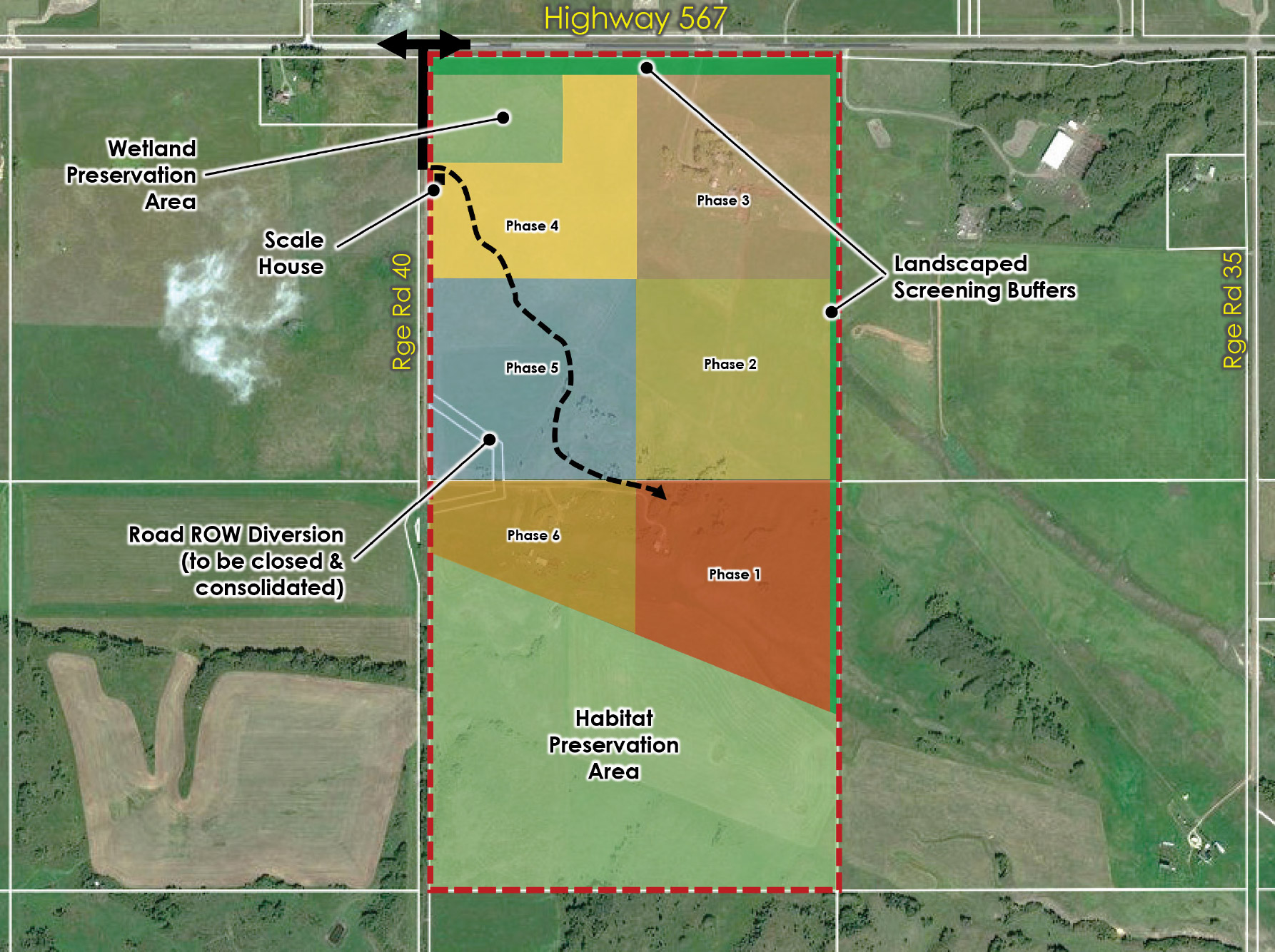
A portable scale will be installed at the entrance to the site along Range Rd 40, south of the intersection with Highway 567. All sand and gravel will be excavated by a front-end loader and fed into a portable crushing and screening spread that will operate within the site as demand for gravel occurs. Aggregate product will be loaded onto trucks from the stockpiles to be conveyed through the scale house prior to being hauled to regional markets.
Aggregate products will be crushed, screened, and shipped to markets around Balzac, Calgary International Airport and north Calgary growth areas. Mountain Ash anticipates a 30 to 40-year operating period depending on market conditions. Development permit approvals will be required to support each phase of the proposed aggregate operations.
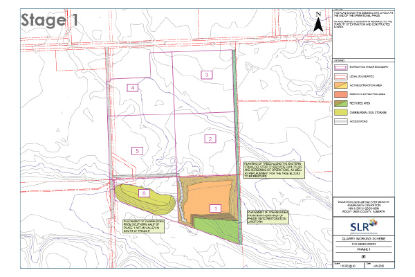
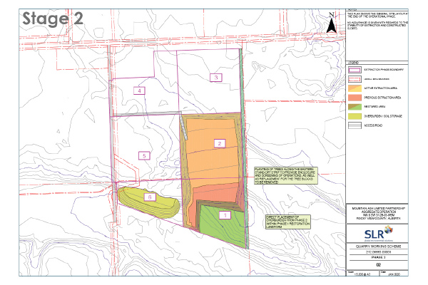
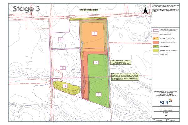
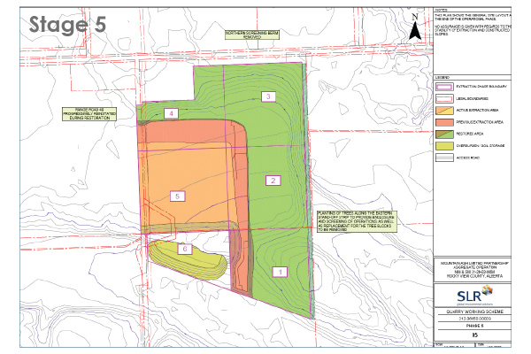
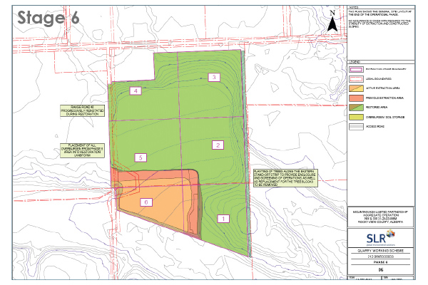
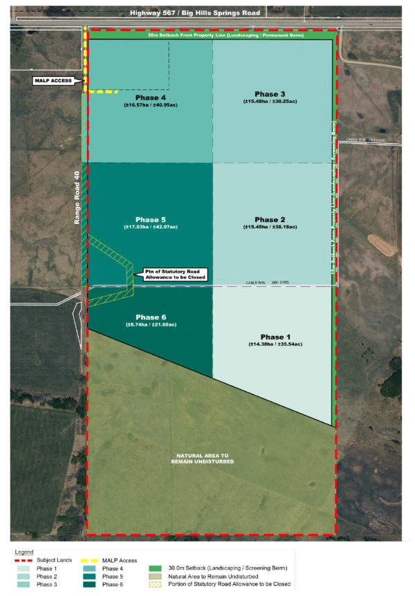 As illustrated below, operations will begin in the Phase 1 area In the SE corner of the site, and will progress in a northern direction before shifting westerly and eventually southerly parallel to Range Rd 40 and concluding within the SW corner of the site.
As part of development permit approval conditions for Phase 5, Mountain Ash will apply to close the existing undeveloped Roadway Plan 552 BM to consolidate the land.
Typical extraction and aggregate production within each phase are expected to include support from one portable crusher, one loader, one bulldozer, and three scrapers.
Potable water and sanitary servicing will be supplied by portable facilities managed by Mountain Ash via a local contractor. Similarly, waste refuse facilities will be provided onsite and removed on a weekly basis and transported to an approved waste management facility.
A scale house and administrative office will be constructed on site in a suitable location to ensure safe and effective on-site logistics.
Hours of operation are expected to occur Mondays – Fridays from 7 AM to 7 PM and Saturdays from 7 AM to 5 PM. No aggregate operations (including crushing activities) will occur on Sundays or Statutory Holidays.
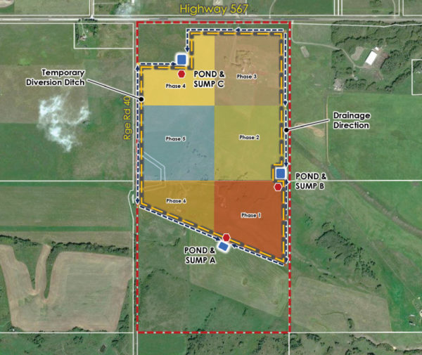 As illustrated by the figure shown here, Mountain Ash will manage stormwater within the site to:
- prevent flooding downstream
- prevent pollution of the underlying aquifer or surface water bodies
- provide a gravity system to contain surface drainage that does not require active pumping
- separately manage runoff from undisturbed areas (clean runoff) whenever possible
- ensure operations are not negatively affected by stormwater runoff
The strategy to manage surface drainage within each phase of operations includes:
- Installing perimeter vegetated ditches at the outer foot of berms along with appropriately sized settlement ponds.
- Excavate a sump into underlying sand and gravel to form an area for groundwater recharge.
- Provide interception ditches to route clean runoff away from extraction areas and allow for overland dispersal.
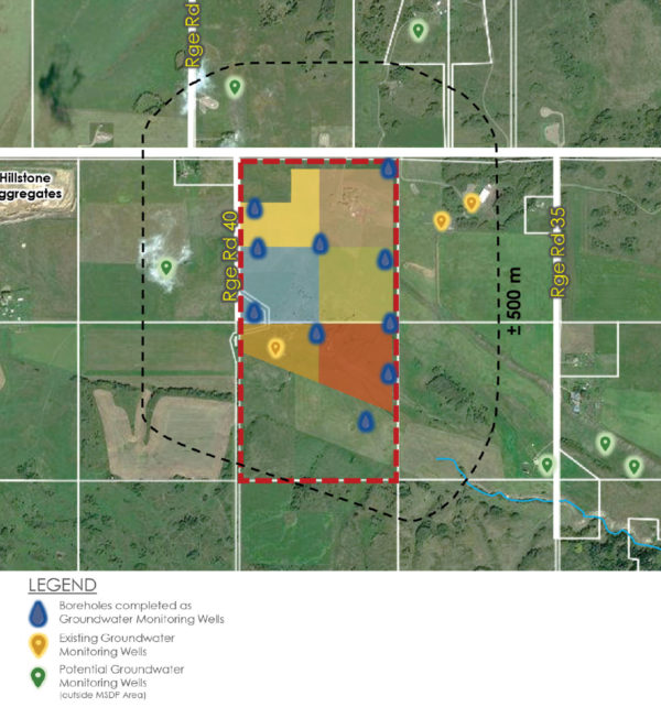
Mountain Ash prepared a Hydrogeological Impact Assessment (HIA) to address potential effects of an aggregate operation on local groundwater. The purpose of the assessment was to determine if the project would affect:
- The confined/unconfined aquifers at or near the proposed development
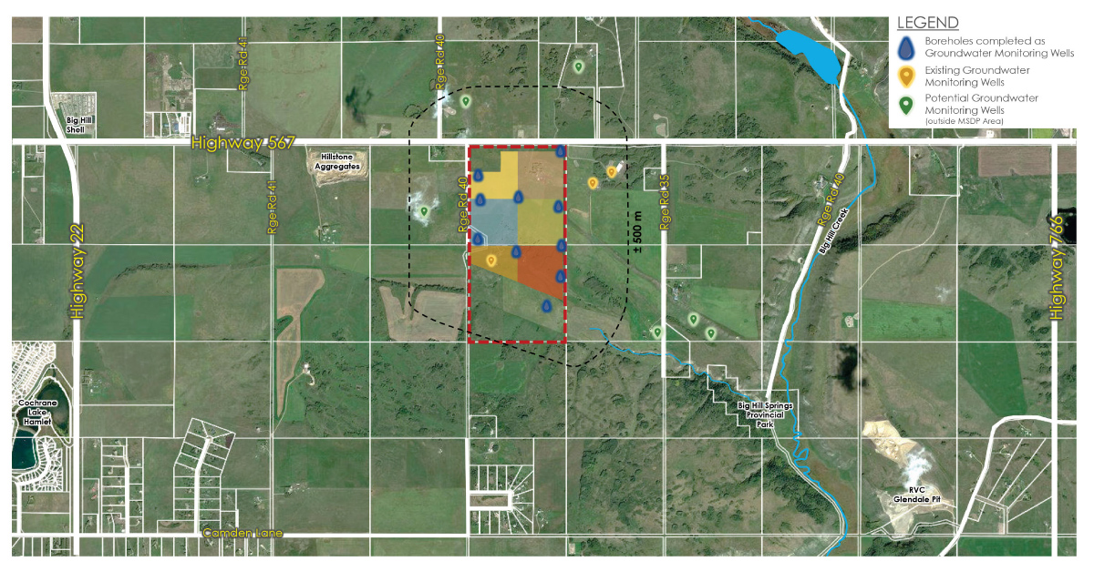
- Neighbours within a +/- 500 m radius of the proposed site
- The Big Hill Creek
The HIA indicates that the proposed project will not pose any significant or adverse impacts to the existing confined or unconfined groundwater aquifers underlying the MSDP area or the adjacent Big Hills Springs. To ensure there are no negative effects to local groundwater conditions, Mountain Ash will limit excavation to a minimum of 1.0 m above the depth of the groundwater table.
Mountain Ash is committed to monitoring the existing groundwater flow system, to give early warning of any unanticipated changes, and to address community concerns related to groundwater. Mountain Ash has already completed an initial two-year groundwater monitoring program to determine pre-development and early development groundwater levels and has installed ten groundwater monitoring wells (with piezometers) within the subject lands, and will monitor four additional existing domestic groundwater wells located situated within +/- 500 m of the MSDP area. The monitoring program will track fluctuations in groundwater levels on an ongoing basis to measure the quantity and quality of groundwater during the lifespan of the operation.
During the operational phase, any potential source of water pollution would be from human caused sources such as fuels, solvents, and suspended solids from reworking the material on site. The potential for these human-caused effects will be mitigated within the site by implementation of best handling practices under the Code of Practice for Pits, applicable Environmental Protection and Enhancement Act rules, and other relevant codes of best practice.
Mountain Ash is committed to reducing the overall impact of its aggregate operations on the surrounding municipal and Provincial transportation network.
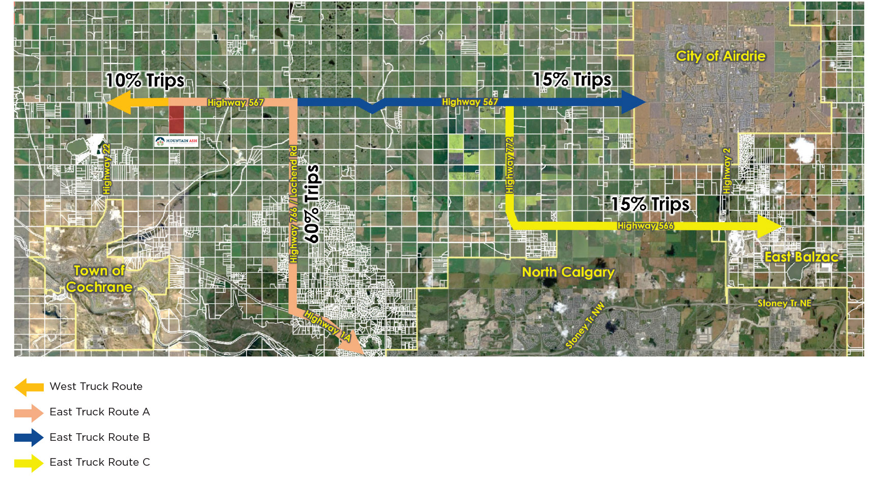
As shown below, truck traffic from the Summit Pit is expected to be conveyed from the site to key markets east of the site, such as Balzac, the Calgary Airport and the north Calgary growth areas via Highway 567. Highway 567 is a provincial high load corridor and ideally suited to accommodate aggregate resource hauling activities.
Mountain Ash proposes three primary transportation routes/networks described as follows:
- West Route: Heading west on Highway 567 anticipated to include about 10% of truck trips.
- East Route: Heading east on Highway 567 anticipated to include about 90% of truck trips, with the following sub-routes described as follows:
- East Route A – Heading east on Highway 567, south on Highway 766, then east on Highway 1A into Calgary to include about 60% of East Route truck trips to and from Summit Pit operation.
- East Route B – Heading east on Highway 567 into west Airdrie to include about 15% of the East Route truck trips to and from Summit Pit operation.
- East Route C– Heading east on Highway 567, south on Hwy 772 (Symons Valley Road), then east on Hwy 566 into Balzac to include about 15% of the East Route truck trips to and from Summit Pit operations.
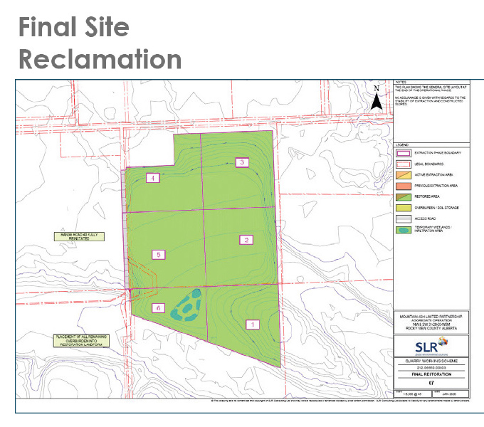
Reclamation will be completed in a phased approach and will follow closely behind discontinued mining operations, with a maximum of +/- 40 acres open for excavation at any time. The site will be returned to agricultural uses upon completion.
The objective of the final reclamation plan is to return the land to an equivalent agricultural land capability after operations are complete. Interim and post reclamation land uses will be agriculturally based in keeping with the historical grazing and pasture activities. No ponding or standing water will be left on the landscape as part of the operations.
During reclamation activities, topsoil and overburden materials will be removed from stockpiles and placed over the reclamation zone. The overburden materials will be placed first with topsoil spread on top to form the surface layer. To optimize efficiencies, efforts will be made to directly apply the overburden and topsoil materials from expansion areas to reclamation zones as opposed to stockpiling the materials in a storage area. Replaced topsoil will be seeded with a vegetation seed mixture as soon as practical to help control erosion and weed growth. Determination of seed mixtures will be based on proper land management practices, such as planned crop rotations and/or grazing schedules. Following seeding, the operator will conduct annual inspections to measure the success of the re-vegetation process.
A monitoring and maintenance plan will be developed and implemented to assess the success of reclamation. This would include field identification and documentation as well as the preparation of a report.
Mitigation Measures
Mountain Ash is committed to addressing potential impacts of the proposed Summit Project through appropriate & comprehensive mitigation measures.


